After coming back from New Zealand on February 3rd and seeing the chaos the new administration was intent on sowing immediately (an upgraded Bannon “Flood the Zone” tactic, now that all the slightly-less-than-ultra right wing folks like Tillerson that might urge any caution against running afoul of the constitution have been expelled from the cult) that could put our future international travel in jeopardy, we decided to take trips closer to home for the rest of 2025. This was both practical financially (if the BBB cuts Medicaid and Tariffs make clothing unprofitable neither of us may have jobs by Q4) and to stay alive (we had planned to attempt a Mexico [originally to be done in summer 2020, but Trump messed that up for us last time too!] trip to swim with whale sharks, but with trump ordering active duty troops to the border and threatening military action in Mexico against the cartels, we decided not to be headless victims of the cartel retaliation).
Oh! Also the staying alive and well via vaccines, which are now being limited or eliminated altogether. I got my first six month booster this year under the pretense it might be the last covid vaccine I’ll ever be allowed to get.
(and yes, this sparked discussions about future 2025 or 2026 medical related trips just to GET vaccines, we might become those “medical tourists” you always hear about)
Then of course there’s the issue of airport security looking at phones and detaining anyone “questionable” because they texted “trump sucks” to their brother once. (Remember this is from the party of Free Speech Vance was talking about in that VP debate!) Then there’s the knock-on effects of the push to end birthright citizenship, which is an obvious first test to the goal of redacting the citizenship of previously naturalized citizens. You know, like my wife.
Of course this looks naive now, since after that decision back in February to change our travel we’ve seen ICE raids at the Home Depot down the street just packing up anyone who looks brown enough. There’s no “let me see your papers,” they just take you anyway, because it was a long drive from Texas, and this is the racist revenge fantasy Daddy Trump promised them back in 2015. We didn’t foresee the quick push to end due-process (after already suspending it for actual people) in our calculations back in February, but it didn’t come as a surprise when it (literally in our neighborhood) got here.
Remember, it’s all just “TDS” until it happens to you! (Malcolm Gladwell is salivating at the opportunity to write a book in 2035 about why so many Leopards have been dying of heart disease and diabetes)
So we decided if we fly in 2025, we’re flying through LAX (local airports still have a modicum of control over their own immigration search parameters), and not very far until SCOTUS does…anything…to reverse the ignoring of due process. We will take a “wait and see” approach to 2026. The New Regime is trying to “move fast and break the law!” to paraphrase Zuck, which supports their agenda as they’ll destroy as much democracy and steal as much money as they can while they can. However, taking the rapid fire approach also means the long arm of the law may catch up to them sooner than if they’d taken it slow. And we’re thankfully seeing that. The “MS13” photoshop knuckle tattoos guy was brought back after folks insisted it was impossible. SOME people working in the Federal government are aware of the the Nuremburg Trials. Or maybe they just watched Dear Leader throw EVERY SINGLE PERSON under the bus eventually and did the “right thing” for their own self-preservation. In any event, this suggests some of the rules of law may yet hold and our worries about travel and detention and all that may be smoothed over as time goes on. I hope. But anyway, that’s for blog posts next year about Australia or Norway or Patagonia or something if we’re still employed by then.
Blegh! So where did I leave off regarding this trip? Well years ago we talked about maybe moving to Oregon if we couldn’t find a house in California (which we very nearly didn’t). But we wanted to actually visit first, and we never ended up going. There was a brief period where we had friends living there, but things got in the way, and they have since moved on. However, with our self-imposed travel restrictions in place this seemed like the right time, also with all the reductions in National Park staff we wanted to see Crater before it was closed or sold off to a Chinese billionaire or oil company. <– I wish that was TDS, but one of the reasons it finally got redacted from the budget bill was because the republicans realized they had no way to sell the land only to American billionaires and corporations. So rather than risk another xenophobic panic like in the 80s when they thought Japan was doing a silent takeover of America with land purchases (and Qanon more recently thought Bill Gates was…sigh…), they struck the sales from the bill at the last minute to meet the President’s stupid demand to get it done quickly.
So anyway, back in April when some of this stuff was already happening and the rest was predictable we booked a “safe” trip to Oregon. And Vancouver, but you’ll have to read all about that next month.
Also, as always, yes, masks everywhere. Every rest stop, every hotel front desk, every gift shop.
Day 1 Friday 7/18
We worked until noonish and then Ubered to LAX for a short flight to PDX, eating dinner in a grocery store parking lot after going to Costco to buy road snacks (and hotel room breakfast) for the week. I was so eager to try the local cider that I bought a grocery store big can and then had to ask Sam to drive the car to the hotel. That hotel was in Vancouver Washington, so we didn’t actually visit the city of Portland.
A short note about the hotel. Not knowing anything about it except the details in the booking description we chose “MyPlace Hotel.” It turned out to be a decent place, recently renovated, larger size fridge, etc. They had a map on the wall with what looked like hundreds of locations all across the US and asked if we had stayed there before. We’d never heard of them before. It made sense when the attendant explained that it was a franchised chain that started by buying out other properties not long ago and converting them all. So, the Subway of hotels. Not the most upscale, but you always know what you’ll get – which when traveling in unknown places is a good thing! We WISHED we could have stayed at another MyPlace in some of the small towns we slept in on this trip!
Day 2 Saturday 7/19
We went to Portland Women’s Forum State Scenic Viewpoint in the morning, intending to drive down the road to other stops, but the road was closed.

So we had to backtrack and skip some things, rearranging the whole day. Most of the waterfalls on our list had no parking left, including the roadside parking for Multnomah. However, we did find a spot at Horsetail falls, so we walked around there for a short bit.


The next stop was Wahclella Falls, which is a longer hike and leads to a large waterfall in a big rock valley. The main parking was full, but there’s overflow parking up a hill. We knew it would add time to our hike, but what choice did we have?

After going over closer to the falls I went back by the bridge and climbed up to take pics on top of a boulder. These videos are me on the boulder trying to find Sam in the crowd by the waterfall and zoom in/out.


As I was coming down a woman started asking me how hard it was to get up there. I joked and said “the hard part is coming down” as I gingerly shimmied down with my butt in the dirt for traction. At the last six feet or so I stood up to hoof it the easy last sandy part of the “trail” and immediately slid and cut up my hand and arm as the woman (now with her husband and kids watching me) started asking if I was okay. You know what always makes a dangerous situation easier, some joker staring at every move you make!
When I found Sam (she’d been staying over by the waterfall) she surprised me with a tiny first aid kit that had been a gift from my employer (for some reason years ago) and she’d quietly packed away on every trip all these years knowing I’d eventually do something stupid enough to need it.
So, a couple uphill sweaty miles later, back at the car we cleaned it all out with our alcohol gel and got some band-aids.
At our next stop, Starvation Creek, we decided to just take quick pics looking up because we were getting hungry.

We drove down to the next little town by Bridge of the Gods, which, like all religions, is a bit of a disappointment when you examine it up close, for fish and chips and clam chowder. I always want gelato after a salty meal, so we tried to figure out the best place for that. Turns out there’s a swanky new riverside park and shopping area on the Hood River called, appropriately enough, Hood River Waterfront Park. The gelato was a bit meh and the constant super strong wind made eating it a little less pleasant than we’d imagined. I can see why everyone goes windsurfing there though.
Then we went to the famous lavender fields and had honey lavender “ice cream” which was technically more like flavored ice water than cream. (they call those slushies where I’m from, but maybe that naming trend hasn’t got to Oregon yet, just the slushy machines)
The pics online made it seem like it was some massive lavender field stretching back to the mountains, but it’s actually very small, about the same size as my childhood backyard. It’s on a low rolling hill, though, so you can take trick photos to make it look like it’s larger.
But I was more interested in the bees anyway.


We then tried to drive to salaheh falls (or something like that). The directions took us to a one way road, but at the end of it. So rather than do a loop and waste a bunch of time we just decided to go all the way to Trillium Lake since it was already 6:30 and we had a long drive to get all the way back to our hotel-er-place in Vancouver, Washington.

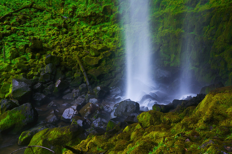
At Trillium we took a few photos and then high tailed it to Multnomah (another hour drive) as the sun was slinking away from the falls. Turns out this is a good time to go since the parking is abundant, free, and the light hitting only half the falls makes for an interesting photo.


Day 3 Sunday 7/20
We drove to Cannon Beach, figured out how to park on the street, and then walked on the sands for about an hour in the overcast kind of gloomy atmosphere. (lots of people still out there, though)

Up the street we went to the local chocolatier before driving down the coast stopping at many viewpoints and driving down Otter Drive.

At Devil’s Punch Bowl we got a good parking spot and realized there was an open fish and chips shop right there, so of course we had a second day of fish and chips and clam chowder for dinner.

After dinner we drove further south and checked into our Yachats hotel before going further south to Thor’s Well.


With a little more daylight we visited the Yachats Sea View park for a very gray sunset.

Day 4 Monday 7/21
We drive down the coast, stopping for photos before turning inland.

We took a very long meandering slow road to get to Sweet Creek Falls trail. The trail itself was nice with waterfalls of varying sizes all along the path. But we didn’t know that at first. When we arrived a group of people were preparing to do the hike, but then saw a sign on the trailhead that said a bridge was out.
They turned around and hopped in their cars and decided to go to another waterfall. We were thinking about what to do when a family finished their hike. They explained that the downed bridge was scalable and showed us a video of an older woman in their party doing it. Well, fine then, we can definitely do it. And we did!


The trail is a few miles long but unlike most waterfall trails it has smaller falls all along the entire route. We stopped often. By the time we reached the actual Sweet Creek Falls we were the only people there. For so long that we sat and had a snack lunch next to the waterfall completely in peace.

I ruined that peace of course a bit later on the way back by going to take some photos and coming back up on a different part of the trail and thinking Sam was ahead when she was really behind me. I ran to the car, realized she wasn’t there and ran back, wishing we had walkie talkies since there’s no cell service in most rural areas in Oregon. In the days to come we’d see many other tourists with walkie talkies for this reason. Eventually we ran into each other and made it back to the car.
Although there was no cell service, GPS still worked and our guide took us deeper into the mountains, in a couple miles Google maps had us turn onto “national Forest road 3840” which was a one lane gravel road surrounded by high foliage in the forest. It was a little dicey but nothing we hadn’t done in an “intermediate” rental car before in other states and countries. I assumed it was a shortcut to the main road because the directions said only to go one mile and then turn left.
About halfway to the turn a giant truck (think lifted F250) came barreling around a bend in this little forest road and almost drove right over us. They braked as I braked and swerved into the shoulder and then …they just rolled through the high foliage past us. It was probably the closest we’d come to a head-on collision, and if it had happened out there in the middle of nowhere that could have been deadly. This mountain road suddenly became very concerning. Even moreso when, at the end of the mile, there was a fork that wouldn’t put us on a “real” road, it would just take us down two other “forest roads” that looked even worse. We looked at the whole map and it would have taken us down these lonely gravel forest roads for….fifty miles!
So we turned around and drove the hour or so backtracking all the way to the 101 and went south to Bannon Beach. We found a popular local crab shack where Sam got crab rolls (and clam chowder) and I got another fish and chips. (you are seeing the food pattern emerge at this point, right?) We had time to reflect and talk about 1) how not to lose each other on trails again (primarily maybe just show up where I told her I would!) and 2) the need on the rest of the trip to check out what roads Google Maps is recommending in the morning for our trip so we don’t die like California Tortoiseshell Butterflies on a rental car grill (don’t worry, I’ll unpack this one later) when a local meets us on the road. 3) Sam might be getting sick of fish and chips. But not chocolate; we found another local chocolatier and ordered a chocolatey milkshake smoothie thingie to share as we drove to our next destination.
Because of all the nasty business on the forest road we were an hour behind our timeline, so we had to scoot along everywhere, but we still stopped at Meyers beach, Arch View, natural bridges, and Whales Head before driving down to our hotel in crescent City. I wish we’d had more time at each beach.


Day 5 Tuesday 7/22
Today we drove inland to a national forest on the border of Oregon and California, to walk among the giants.

However, since we’d already walked among the giants in Sequoia and also in New Zealand, this walk wasn’t super impressive. What was a bit more impressive was the forest road you need to take to get in and out of the grove, which entails a few miles of driving squeezing between and sometimes through the redwood trees.
Then it was a two hour drive down country highways behind coal rollers and generational ranches now owned (at least in spirit) by the Trump Crime Family, as is the custom to hang the new king’s crest over your own (apparently). Often the ostentatious bootlicking was accompanied by a splash of Gadsden on the side for additional unintentional irony. They should really cross out the “N’T” on that flag at this point! Let me unpack a bit. On this trip we would visit many national and state parks and eat our breakfast next to lakes and rivers. For us this was a decision that served two purposes: 1) to eat outdoors and avoid covid and 2) to be in the nature we came here to enjoy. Often we’d be accompanied by fishermen attempting to get a free taste of salmon and other local fish kept healthy by protecting the lands as a national public resource. The bumper stickers on their trucks? You guessed it, the leader of the party that tried to sell off hundreds of parks in the “Big Beautiful Bill” last month and who has done “generational damage” to Crater Lake National Park. But they’ll keep flying those flags until they get arrested for coming to fish one morning. And it’ll be Biden’s fault, or Obama’s fault, or CBS’s fault, Soros too, why not? An abandoned business we passed on the road one morning had at some point in the past replaced the letters on their business sign with “TRUMP WON FAFO.” Endlessly confusing when you don’t know which Trump era this is from. Also confusing when you do. If the “FA” is poor people getting healthcare, then surely “FO” is death. I wonder why the place went out of business.
But it gets worse. The internet being what it is, I was curious if anyone else noted this. Either someone saw something ELSE in rural Oregon with the same message or the business was actually a church (which, is actually a business anyway that just doesn’t have to pay taxes, which is worse since they’re supposed to be tax exempt by staying OUT of politics, not putting it up on literal signs for their customers…DOGE…where are you? Some tax fraud happening here…helloooo?!).
Quick reminder that Oregon’s Medicaid program is funded over 75% by the federal government. Lots of small town hero coal rollers going to fund out (not a typo) the hard way soon. That’s the FAFO that’ll really happen due to that Trump win, but it’s going to be Hillary’s server’s fault or Hunter Biden’s laptop’s fault or something when mom can’t get her insulin anymore, right? According to Oregon Health Authority (an arm of oregon.gov), it’s going to be the rural areas hurt most. I know you didn’t think this was where this blog post was going, but neither did we. There we were on long drives through nowhere staring at people proudly pointing those guns at their boots and itching to pull the trigger in defiance of…whatever the TV tells them is bad about California this week.
Eventually we passed through enough small towns to reach the combo waterfall hike of Barr Creek and Prospect falls.


Both very large falls cascaded over a cliff in a narrow gorge. After some time we did find the way down the cliff to the bottom, but decided not to go as it would be very slippery and time consuming.
Only five minutes down the road was Pearsony Falls, which was easy to get to, albeit much much smaller vertically than its neighbors.
The ability to sit next to the rushing water completely alone for the first 20 minutes is not to be discounted. This is the “forest therapy” you’ve read about.

After this we ate at a roadside BBQ truck in Prospect. We had about a quarter tank of gas left and weren’t sure if that would get us up to let alone around Crater. Especially since part of the Crater loop was closed for repairs. Some people in Prospect said there was no gas anywhere but Shady Cove (back 35 miles). Others said there was a gas station at Crater. Of course WHERE in Crater, a 33 mile circular drive after you drive 20 miles to get there, was the central issue.
We decided to chance it and watched our fuel efficiency drop precipitously (thanks, Nissan!), losing about three miles in range for every real world mile we drove, quickly taking us into the realm of no return. For those of a certain age this is known as Kramering.
At the top we came to the park entrance and the ranger assured us there was gas in the park, in fact it was only a few hundred yards from the ranger station. Phew! So we filled up and drove all the way around the crater to reflection point, where the road was closed until September for renovations.


The drive back to Shady Cove felt much longer than the hour on the map due to the absence of sunlight and people. For long stretches of completely straight roads (here and a few other spots in Oregon) there were few other vehicles, leading to the creepiness that folks sometimes associate with rural Oregon. I can see why folks fantasize about seeing Sasquatch; for anyone living alone up here it may be the only other “person” they see for a while and humans need socialization. The brain invents what it needs to.
That said, at one point in the route the sun was setting directly on the road through the tall pines, like a backwoods version of Manhattenhenge. Due to the speed we were traveling I failed to get an unblurry photo.

Day 6 Wednesday 7/23
We returned to Crater, stopping at a few waterfalls and overlooks.

At many of the overlooks there were swarms of orange California Tortoiseshell butterflies that constantly flew past us. This would continue for a few days everywhere we went around Crater. The swarms were hard to capture on camera for obvious reasons, but that didn’t stop me from trying.


Then it was on to Watson Falls which was very easy to get to and you could walk right up to the base of the massive high waterfall. There were only maybe six other people up there and the spray from the falls was a welcome respite from the full Oregon summer sun.


At the next stop, Toketee Falls, we weren’t so lucky. There was a bus unloading about 50 teens with badges and identical purple shirts. We tried to outrace them to the viewpoint, but failed and remembered how old we are. The viewpoint itself was a bit of a fail too since it was off to the side and made of bouncy stuff; I wasn’t able to get a decent shot off before they started cycling through.

There was a trail down to the base of the falls which I could have taken, but it was risky (I am trying not to take these risks anymore) and would have left Sam waiting forever. Instead we hopped down safer overlooks on the way back.
We drove to Diamond Lake for dinner and checked into our extremely redneck themed hotel in Crescent. The interior reminded me of the Da Yoopers song Second Week of Deer Camp; camo everything, ancient appliances (an actual 90s Sony Trinitron like we had when I was 12), stuffed animals mounted to the wall. The bathroom even had deer themed shower curtains.
The next room was occupied by two young (to me) guys who sat outside in silence drinking cans of Coors Light for hours looking tired and miserable. Likely working in the logging industry and moving about to follow the jobs. Having grown up in a place adjacent to this aesthetic the fun of the woodsman facade fades fast and leaves you with thoughts of what the lives are really like here, miles from nowhere in towns that don’t even have a stop sign. I know-er knew-plenty of guys that graduated high school and needed a job so they took the first manual labor that paid. That look of constant exhaustion, not even able to laugh with “the guys” after a few beers anymore, is something I’ve seen before. It was at this point in the trip that we both verbalized to each other the discomfort about these towns that was boiling just beneath the surface. More than once we’d stepped into a restaurant and started the red-hatted head turning that felt like one of those scenes from a movie about a sundown town. Yes, I had to explain what sundown towns are on this trip to my wife and how she probably shouldn’t leave the motel room unescorted. The looks were definitely there, and as an immigrant she’s got more experience recognizing them than I do, but they weren’t hiding it at the restaurant or the gas station or the motel front desk. It was palpable and anxiety inducing; we got gas more frequently than we planned just on the off chance we’d need to “escape” a “situation” at some point on one of these empty roads.

Day 7 Thursday 7/24
Today we allocated about 5 hours for the “scenic byway.” However, once there we didn’t really come across any amazing overlooks or viewpoints or anything resembling the “scenic” designated roads in Colorado, or California, or even the Otter one on the Oregon coast. Instead the viewpoints were often just a pull-off with a picnic table in the middle of the woods. There were a few lakes as well, but “nothing to send postcards to your nephew about” as the saying goes.
As such, we arrived in Bend much earlier and spent the rest of the day in town, taking a much needed hipster break from the TRUMP CUNTREE surrounding it.
That break included Costco, of course. After Costco we went to the only Butte in town before checking into our swank (but no hand soap?) hotel. We wished we’d just drove here last night and booked two days instead of hanging in Deer Camp.
We hung out in the room AC for a few minutes listening to Chuck Mangione (rip) and checking long neglected work emails before going downstairs for “happy hour” where the hotel gave us free wine, olives, and blue cheese to eat on their outside patio.
Properly inebriated we ambled down the riverbank path to the music and food weekly riverfront festival. However, we decided not to stay and eat the food truck fare. We walked a few blocks back into town and found a Mexican restaurant with nobody sitting outside in the late afternoon sun. A busker across the street belted out an hour of soulful tunes on his saxophone while we sipped on margaritas. A stark and welcome contrast to the dour emptiness of Crescent. We walked back and wondered how expensive the riverfront homes were. Too expensive, it turns out. We would never have ended up in Oregon anyway, it seems.
Day 8 Friday 7/25
Friday we started on our way from Bend to Salem. We drove up through volcanic rock switchbacks in burned forests and eventually down into a lush valley to visit Proxy Falls. The lower falls was spectacular; after crossing a log you hike up to the base of a high waterfall and make yourself comfortable among moss covered rocks.
There were only a few other people there and it was easy to get up very close to the falls even though they were loud and wide and long.


After that we went a short way further to the “upper falls” which is a very different waterfall. This one starts at the same height, but slowly trickles down a rock fall hundreds of feet downhill until gently tinkling into a shallow pool right on the trail. Nobody else joined us for this one.

Next we drove up to a duo of waterfalls that was much much more famous than the duo of upper and lower proxy. At this one there was no parking, we had to park up on the freeway and walk back down. These waterfalls were also impressive, but were not as intimate an experience, and much more of a tourist destination.

After looking at Sahale from the viewpoint we decided to hike down to the Koosah Falls viewpoint, where we had the experience of watching an amateur free diver in a wetsuit jump from a log on top and swim to the shore, hiking up to the viewpoint where his girlfriend was waiting to soothe his literal wounds. He had a cut on his face when we saw him, but we ran into him again at Silver Falls (not suited this time) the next day and he had a black eye and other bruising from the dive on Friday. One wrong move and he’d easily have been dead, but at the same time I have to admit as a wetsuit owner who’s done canyoneering in Swiss canyons….I was jealous.


We continued downstream to find a better view of the falls and found a very cool “pandora-esque” combination of fallen trees with moss and newer trees rooting through them. We spent a little time hanging out there before heading back up.

The easiest (but not safest) way back up to the trail was to walk high in the air on one of the fallen logs. Sam got right to it. I saw something spark in her this day and she was more adventurous than the last few months. We used to get into all kinds of trouble on our trips, but I think the effects of aging and the current political climate have taken a toll on both of us. I was happy to see her get reinvigorated and jump out onto iffy rocks and goad me into following. The way to get to that tree in the photo above is not extremely difficult, but it is dangerous, and what you can’t see is that the creek rushes by right under it, so if you slip, you might be dead. But she was over there before I could even look up from my camera to stage a (without humans) shot. And then while I was thinking about the safest way to get back up to the trail…she was already just hiking up a mossy log!

For a few years until this moment she’d held back and said “you go if you want to, I’ll wait here,” at places like this, but today she was out there climbing on slippery roots over 50 foot falls into rapids while I was still debating if I should.

After this adventure we were hungry so we drove to the nearest town (about an hour) to a roadside diner for some terribly unhealthy, but given the circumstances satisfying, Americana (onion rings, mashed potatoes, fried this that and the other thing, etc.).
We drove on to our hotel in Salem and called it a night
Day 9 Saturday 7/26
While driving to the hotel yesterday I felt sick for about twenty miles. Probably the wheat in the onion rings or maybe just too many calories in general. At one point I debated pulling over and asking Sam to drive, but I never said anything and ended up feeling better. By the time we checked in I just felt bloated. The next morning I noticed that the skin around my eyes was swollen. This was similar to the allergic reaction I went to the ER for a few years ago, but unlike that day, my throat wasn’t swelling so I didn’t feel it was that dangerous. We’ll never know if it was the food or something else, but Sam swears my eyes were swollen by the time we got to the hotel so it was probably the slice of “Americana” we ate in the little town. A fitting metaphor I suppose, I’m certainly philosophically allergic to their politics.
All that is to explain why, if you look closely at the photos from Saturday, you’ll see baggy eyelids on my face.
Today we only had one destination, but it’s known to take all day: Silver Falls State Park.
Our first stab was the southern falls out and back. This park features at least three different waterfalls that allow you to walk behind the falls.


After seeing these two we decided to drive up to the north parking, but had to go to the overflow. We knew it might take a while to hike up to the four different falls, so we sat in the car and snacked first.
And it did, it took about two hours to get out and back, not all the falls were super impressive, but a few were worth photographing.


After this we had hiked about 8 miles already and decided to skip north falls altogether and head to the roadside view of cathedral falls. However when we got there we found that the roadside view didn’t exist and it was the start of a short trail….we were suspicious though since the falls weren’t on most of the placards throughout the rest of the park. (We couldn’t research any of this online as, like almost everywhere outside of the cities, there was no cell service) As we started down the trail we asked the first man coming back up if it was with the effort. He said no, and we should go to North Falls instead since it was late already. So we turned around and drove to north falls trailhead. It was about 7pm so the parking had thinned out (we skipped it earlier in the day because there was no parking). The hike down to the falls took only about fifteen minutes, and it was another falls that allowed you to walk behind it. I could be wrong, but this one felt like the widest walk around in the entire Silver Falls park.

The only downside was that at one spot I stopped to take pictures (I think the one above) we smelled something really bad. I said “why does it smell like shit right here?” and Sam said “because it’s right next to your foot!” Sure enough, there was human excrement just laying on the path there in one of the wet waterfall puddles. Disgusting. We spent the rest of the hike back stopping off at the creek and loose moss and everything possible to wash and scrape off the nastiness that we may have stepped in.
The whole thing was bizarre since only a few feet away from where the person did their business there was a little platform at the center of the back of the falls where even at 7:30pm there were three teenage girls taking tiktok videos of each other posing behind the waterfall. How somebody did what they did only a few feet away from Instagram central I have no idea. It was really the only downer on an otherwise fun day of waterfall hopping. Also, the hike wasn’t that long and there were bathrooms at the parking lot, so WHY?!
This was our longest walked day by far, tallying over 9 miles by the end and over 22,000 steps. However, the good news is that all the walking around our neighborhood and up and down our stairs (and a walking desk for me) at home had us better prepared than on treks like this in the past. Sam started to feel it in her ankle just on the last hike and I only barely felt the slightest irritation in my knees. We brought our knee braces that we had to wear in years past, but ended up not wearing them. No shin splints this time, no walking backwards to avoid knee strain. Sam has also been slipping collagen powder in my morning coffee every day since we moved into the house and she got a nice coffee machine.
Day 10 Sunday 7/27
On our last day in Oregon we went to the city of Portland reservoir for a few minutes. However, before we got there we saw a sign for rock sale down the street so we turned the other direction from the park and checked out the sale. It was in a couple’s garage and was chock full of mostly small cheap amethysts. (yes, mom, the purple ones) However, there were a few mounted pieces that caught our eyes. I decided to get a smaller one for my office since they seemed cheaper than our local rock source in Frogtown. Oh yeah, I haven’t mentioned here before that we started frequenting Frogtown since it’s only a few miles from our house and is a rapidly gentrifying neighborhood with a bike path along a part of the river that’s been rehabilitated into a wetland with plants and birds and the whole thing. And restaurants…and a rock shop. The first time there we found a cool green rock and dropped $80 on it, which now sits in our living room window. This garage in Portland had much larger pieces, but lower prices and not much variety, so we were compelled to look (and for me, buy). We chatted with the proprietor and she said we were the third couple to stop in this morning on their last day before going back to LA. As we were paying Sam asked how much a blue rock (celestite) was that she’d had her eye on earlier and the lady said “just take it.”
We asked her to pack it in bubble wrap and we found a safe spot for it in our luggage before driving the long way through Belmont to downtown to the market for lunch at a Thai place with outdoor seating.
After lunch, Sam, having been to Portland once before, put on her tour guide hat and navigated us around to Old Town, uptown, etc. we parked in Uptown and visited an ice cream shop. Sam swears it’s the best Ube gelato ever, I’ll just commit to saying it was really good. We noticed we parked right in front of a spiritual goods shop that advertised crystals. Stepping in and looking at their amethyst prices we realized how cheap the garage pieces were.
We drove back to the rock garage and bought the larger amethyst piece we’d been ogling earlier that morning. Then went straight to the airport.
At the airport my bag was set aside and the rocks pulled out and handled for inspection because rocks look “weird” on the scans. I thought Portland liked weird.
